3D Architecture Rendering
What is 3D Architecture Rendering, and how it help Property Developers?
Developing two-dimensional and three-dimensional pictures of a proposed architectural design are known as an architectural rendering. The purpose of 3D Architecture Rendering is to create realistic representations of how a room or building will appear before it is constructed. For property developers, there are essentially five sorts of 3D rendering possibilities. The following are some of them:
Aerial renders
3D architecture rendering helps in the Aerial display of the property, emphasizing the surrounding landscape. They are useful for demonstrating how the new structure will blend in with the existing surroundings.
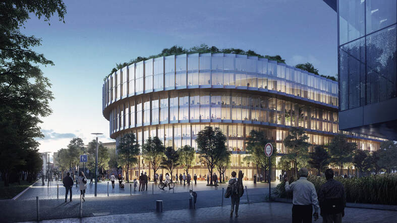
3D exterior renderings
The exterior of the buildings and their surroundings are the focus of the 3D exterior render. You can choose between a render that focuses solely on the structure in perspective or one that incorporates the surrounding neighborhood and amenities such as fences, water bodies, porches, and plants. This can be turned into eye-catching marketing materials.
Interior renders
Interior renders depict the property's 3d Interiors from a different perspective. Developers can exhibit one room at a time or a panoramic view of numerous regions such as corridors, doors, and the layout of various facilities in the lobby.
Floor plans
Traditional 2D floor plans are given more depth and detail using 3D Floor Plan renderings. Potential buyers can envision themselves in the property or building and grasp various parts' spatial arrangement using floor-cut renderings.
Walkthroughs
The most valuable deliverable is 3D Video Walkthrough a output that allows the client to experience a lifelike virtual tour of the property. Before the actual construction process begins, this animation allows potential buyers to take a virtual tour of the structure. They will get a good feel for the property's atmosphere, layout, and features.
Final thoughts
Thus, a 3D render is a photo-realistic image created by converting a CAD/PDF file containing a site plan, elevations, floor plans, and sections into a 3D model. And this creates a photo-realistic image.
Developing two-dimensional and three-dimensional pictures of a proposed architectural design are known as an architectural rendering. The purpose of 3D Architecture Rendering is to create realistic representations of how a room or building will appear before it is constructed. For property developers, there are essentially five sorts of 3D rendering possibilities. The following are some of them:
Aerial renders
3D architecture rendering helps in the Aerial display of the property, emphasizing the surrounding landscape. They are useful for demonstrating how the new structure will blend in with the existing surroundings.
3D exterior renderings
The exterior of the buildings and their surroundings are the focus of the 3D exterior render. You can choose between a render that focuses solely on the structure in perspective or one that incorporates the surrounding neighborhood and amenities such as fences, water bodies, porches, and plants. This can be turned into eye-catching marketing materials.
Interior renders
Interior renders depict the property's 3d Interiors from a different perspective. Developers can exhibit one room at a time or a panoramic view of numerous regions such as corridors, doors, and the layout of various facilities in the lobby.
Floor plans
Traditional 2D floor plans are given more depth and detail using 3D Floor Plan renderings. Potential buyers can envision themselves in the property or building and grasp various parts' spatial arrangement using floor-cut renderings.
Walkthroughs
The most valuable deliverable is 3D Video Walkthrough a output that allows the client to experience a lifelike virtual tour of the property. Before the actual construction process begins, this animation allows potential buyers to take a virtual tour of the structure. They will get a good feel for the property's atmosphere, layout, and features.
Final thoughts
Thus, a 3D render is a photo-realistic image created by converting a CAD/PDF file containing a site plan, elevations, floor plans, and sections into a 3D model. And this creates a photo-realistic image.